The City of New York about 200 years ago
Map extension from The Battery to the 96th Street
D.T.Valentine's Manual 1853
(Rivised but unaltered edition of 1807)
Lith. by G. Haywarth, 120 Water St.
This edition was reduced to 1/2 Scale
Actual size approx.
58 x 50cm or 23" x 20"
Unfortunately it is of very thin paper and suffered some broken neatlines, but nothing is missing
Here follows a very personal impression: It looks like an old winebottle label, doesn't it. In reality and without my framing it is just part of a sheet map of New York from 1807. Unfortunately nothing known here about the vintage of 1806 in France. Anyway, if it was a good year in Burgundy, Napoleon drank it all in June 1807 at the armistice of Tilsit together with Tsar Alexander. By the way, during that happy occasion he split Prussia in half and asked 154 millions of French Francs as indemnity for a war Napoleon started himself. Well, he got his Beresina and he deserved it. Neither Prussia 1871 in Versailles nor France in Compiègne 1918/1919 were wiser. Sorry for loosing track. It was the winebottle label's fault.
The unvisible lower half of the sheet shows part of Brooklyn. At the right lower corner appears a list of 87 references from the Government House at the Battery, specifying also Churches, Markets, Prison, ending at the State Botanic Garden near the four mile stone on the Fifth Avenue. I thought I knew Manhattan well, but by now I know it quiet better. As my longest stay in Manhattans endless streets is always behind the Half Price Ticket Boot on Times Square, I will show further down this small detail as a red dot on the map.
It was very interesting to me to compare this revised, but still unaltered edition of 1807 with Valentine's Manual of 1860. You can find this edition at Stuart Brorsons homepage: Vintage City Maps.
It's astonishing how Manhattan grew. Getting half burnt down by the Great Fire of 1835, including some Insurance Companies and consequently not paying compensation, the City grew faster than before.
Somebody could tell me the meaning of THE PNR NDE or so situated on the vast white spot? It is written in very fancy capital letters of long time ago. This huge area without any streets is situated between the 12th and 34th Street and the 3rd and 7th Avenue. The eastern part of this area became later Madison Square Park.
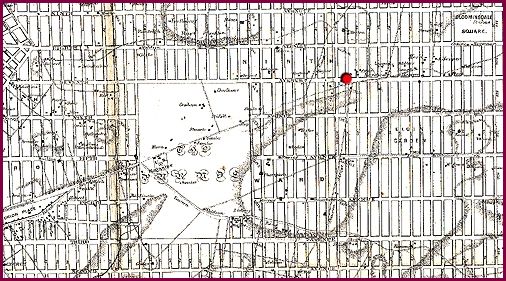
Just to feel familiar with this map section, I marked the crossing of the 7th Avenue with the 43rd Street, exactly the Half Price Ticket Boot on Times Square.
